Pages

Wednesday, 18 December 2013

Cloud Quarry and Loughborough from Derby

This ride follows NCN Route 6 into Leicestershire, and as far as the crossing of the A42 trunk road, it is one of the longest traffic free routes in the area. Also it has a good tarmac surface for most of the way and since much of it is in the Trent Valley, there are no significant hills.
The focal point is Cloud Quarry, a quite spectacular hole in the ground, and from there we have several options for the return journey, these being indicated later.

          We join the Riverside Path at Five Arches Bridge which is close by Derby's railway station.

                                                   Following the River Derwent Eastwards.


 A new sight ahead; the twin wind turbines erected by Severn Trent Water on Megalaughton Lane.
      The plume of steam is emitted from the cooling towers of Radcliffe-on-Trent Power Station.

                            The path meanders along the river bank towards Alvaston Park

                            See the Derby Velodrome under construction to the right of the path.

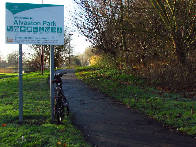
        Go beneath the vandalised railway bridge to leave the river bank and turn right into Alvaston Park.

                                                                   On this path.

                                               Alongside the placid waters of Alvaston Lake.


 On the right "the listening ears" which amplify sounds over a distance of about 100m.

                                                           Follow the path to the left.


Keeping on the Canal Path.

 
                                  There are several roads to cross and most have Toucan crossings.

                                              Ahead is the Chellaston Road bridge at Shelton Lock.


                           Having crossed Sinfin Moor Lane we head towards Swarkestone Lock

                                                          Over the narrow bridge.


                                                    And beneath the A50 trunk road.


Almost at Swarkestone Lock now, with the Derby Canal bed to the right and ahead a restored bridge at the junction of the two canals.


From the bridge over the Trent and Mersey Canal looking towards Stenson we see Swarkestone Lock.


                            Cross the bridge turning left onto the towpath below.


            The towpath is narrow but has a decent cycling surface from here for well over a mile.
                             Look back to see the bridge which we have just crossed.

After passing beneath the railway bridge we come to Cuttle Bridge, which carries the A514 road between Chellaston and Swarkestone village.


                                  Nice reflections in the waters of the canal at Cuttle Bridge.

                                                   Beware of oncoming cyclists
 
                                   Follow the towpath towards Weston-upon-Trent.

    Leave the canal towpath here, turning right at the redundant railway bridge to join the railway path.


Cross the River Trent on this concrete surfaced viaduct. This river crossing was a vital link in the construction of the cycle path since other river crossings at Swarkeston Bridge and Shardlow are far away.


From the Trent Viaduct, the cooling towers of the defunct Willington Power Station can be seen across the flatland of the Trent Valley.


The path is in a cutting here so we cannot see the nearby villages of King's Newton and Melbourne. These lovely stone bridges carry local roads across the path, but of Melbourne Station there is (sadly)
no trace


This Sustrans milepost stands on the border between Derbyshire and Leicestershire.


                                                                 Here be Derbyshire.


                                                        And here be Leicestershire


                                Tonge Station, now a private house and small touring caravan site.

                           From Tonge Station we climb up a gradient towards the A42 bridge.

And see Breedon Church standing high on the hill to our right.  On reaching the road ahead, turn right to visit  Breedon where there is an excellent cafĂ© at the Garden Centre, and you can climb the hill to the church where there are spectacular views of East Midlands Airport and Charnwood Forest.
Alternatively turn left at the road, cross the A42 bridge and follow the Cloud Trail to Cloud Quarry.

                                                                  Pass the stud farm.


                                                  Take the path to the left, and go under the bridge..

                                 Here is the Cloud Trail, another reclaimed railway route.

                                                Turn left at this sign for Worthington.

                                       Climb up the hill, keeping the quarry fence on your left.


At the summit is this view of Cloud Quarry where thousands of tons of limestone has been extracted for many years.

              Opposite and alongside the path are these mythical creatures called the Rock Drills.

Another return option from here is to follow the outward route back to Derby, and this is the best option if you wish to keep the whole ride off-road.
Otherwise if you wish to continue on to Loughborough, carry on along the path until you reach the public road at the top of the next climb.  The remainder of the route is then mainly on public roads, some of them country lanes but others can be busy with traffic. Generally they are well marked as NCN Route 6 or the Garendon Trail. You will pass through Osgathorpe, Belton and Shepshed,  before reaching Loughborough,  from where you can catch a train back to Derby. A single ticket costs between £5 and £7 dependant on a Railcard.

Finally, as I rode into Lougborough on completion of this survey, the sun was setting on the West side of the A6 road, and I managed to take this final photograph as my camera battery ran flat.


Friday, 13 December 2013

Take Your Bike by Train

Trains and bikes make an ideal combination if you live within easy cycling distance of a railway station. You can cycle to your station, take the train to somewhere else, have a nice circular bike ride, or cycle to a third station and return home by train.
Travelling by train can be expensive, but the Internet allows us to search for the cheapest fares, and there are some bargains available, providing that you can travel off-peak, when the trains are less busy. Also you need to book well ahead of your proposed travel date, and this means that you have to take a chance on the weather. 
Another problem is that modern trains have very limited space for bikes, and to be on the ball here you need to have a cycle reservation, which is free, and get that before some other cyclist gets in  first.  If you have a folding bike, no problem, since these are carried as luggage and there are no such restrictions.

Sometimes an Off-peak Day Return is the cheapest and sometimes two single tickets are better.
Surprisingly, return tickets are often only a few pence dearer than one single ticket.
Having a Railcard brings reductions of about one third off the price, but the card costs £25-£30 per year. There are many categories of Railcard.

So first decide when and where you wish to go, trawling the rail ticket Internet sites for fares which are good value.  You need to be flexible here, changing your preferences as necessary to get best value.

Having settled on a trip, you pay by credit card on-line, but cannot get a bike reservation. For that you need to apply at the station ticket office. Although you can have rail tickets sent on to your home address, it is best to collect them from your home station where there is a machine which prints them off.  You then take those tickets to the ticket office and ask for cycle reservations.

In the good old days, you had one ticket for the journey, but sadly those days have gone, and you are inundated with a ticket for every eventuality.


Above no less than 14 tickets of various kinds for a simple return journey with a bike from Derby to Coventry.
They are as follows.
1. Derby to Coventry (only valid with seat reservation ticket).
2. Seat reservation ticket for D to C ( I did not want a reserved seat but it is mandatory).
3. Cycle Reservation (attach to cycle).
4. Cycle reservation (passenger copy).
5. Coventry to Birmingham (only valid with unwanted seat reservation).
6. Seat reservation ticket for C to B.
7. Cycle reservation C to B, attach to cycle.
8. Cycle reservation C to B (passenger copy).
9. Birmingham to Derby (only valid with seat reservation)
10. Seat reservation for B to D.
11. Cycle reservation for B to D (attach to cycle).
12. Cycle reservation (passenger copy).
13. Collection receipt (credit card receipt which looks like rail ticket).
14. And finally, in the centre, Senior Railcard.

The outward journey Derby to Coventry was on a single train, but had there been a need to change trains at Birmingham as on the return journey, a further three tickets would have been issued.
What a crackpot system!
Having said that, the total cost of £6.60 for the return journey with bike is very good value.  A recent one-way trip Derby to Sheffield cost only £2.63.

Wednesday, 11 December 2013

Borrowash to Derby

As a cycling route this is a peep into the future, being only really feasible today as a walk, but one day will no doubt become another link in the National Cycle Network.
We start on Station Road in Borrowash, on the bridge which carries the B5010 across the Derby to Nottingham Railway, and where once the road spanned the Derby Canal. To the South the road also crosses the River Derwent and less than a mile away is Elvaston Country Park, home of Elvaston Castle.

The blue sign stands on the line of the Derby Canal, and in a cutting between the walls on the left lies the railway.


The photograph (right) was taken from the top of  the steps which lead down from the road to the path.
Behind us here, Route 6 of the National Cycle Network goes off-road towards Draycott and Breaston, having come from Derby on the South side of the Derwent along the Riverside Path.


           Ahead the path looks enticing, and to the right recent earthmoving shows the line of the canal.


                 This bridge, which once spanned the canal, is nice and has been restored, but would  look  much better with the waters of the canal beneath it.

                                                  View looking back before the bridge.


                                                         A nice view through the bridge.

 This is where the route becomes more suitable for boots than tyres, and where it will be necessary to build a better bridge than this to carry bikes across the stream which lies beneath.


                            Definitely a footpath here, but fortunately only a short stretch.

                  Since before long we emerge onto a tarmac road alongside this new housing estate


The tarmac ends here, but fear not, as the narrow path continues against the metal fence on the left.

                             The railway is close by to the left here, hence the substantial fence.

                               The path improves now as we enter Spondon Linear Park.


                             More signs of the canal with the remains of a bridge here.


Although the path continues beneath this bridge, dubiously decorated, we should leave it here (left) to regain the road (Station Road) where Spondon station, with it's level crossing lies alongside. Keeping to the path ahead reveals a "winding hole" where long barges could be turned round. This feature is being refurbished by the Derby and Sandiacre Canal Society.  The straight ahead path emerges alongside the Spondon B&Q Store and Raynesway, so not good for cyclists or walkers.

For walkers, the best plan here is to cross the bridge into Spondon where a bus back to Derby can be boarded.
For cyclists, go over the level crossing to join Celanese Road which leads onto Megalaugton Lane and hence to the Raynesway Cycle Path, and after crossing the River Derwent, regain the Riverside Path back to the City Centre.