In the days of steam, the Great Northern Railway crossed the (then) town of Derby from North-East to South-West with Friargate Station in the centre. After closure by the infamous Dr. Beeching, most of the middle portion was demolished leaving the disparate end sections derelict.
In more recent times the remains have been turned into off-road parts of the National Cycle Network and very popular have they become.
Locally they are known as the Mickleover Greenway and the Breadsall Greenway, rather than the overall official nomenclature of the Great Northern Greenway.
The Breadsall Greenway is Route 672 of the National Cycle Network and has two disadvantages - one that it's start is some distance from Derby City Centre, and the other that "it goes nowhere" according to some critics.
In this slideshow you will see that it is possible to cycle almost all the way off-road so it is a suitable and attractive ride for even the most nervous of cyclists.
Fifty one pictures, so take a seat and enjoy the ride.
Click on pictures to see them full screen.
If you have a SmartPhone you can refer to the pictures as you ride the route.
 |
Most of Derby's National Cycle Network routes meet at Exeter Bridge close by the Market Place, so we cross the River Derwent taking the Riverside Path opposite here.
|
Initially we are on NCN Route 6 which is well signed,
 |
The path runs alongside the river, beneath the Inner Ring Road and out of the city centre.
It is one of our most popular local cycle routes. |
 |
| We leave Route 6 here turning left onto the cycle path which runs alongside the Trent-Barton bus garage. |
 |
| And follow it towards the Pentagon Island |
 |
| And under the bridge. |
 |
| We circumnavigate the Pentagon Island in an anti-clockwise direction using no less than five Toucan crossings. |
 |
| The first takes us across and to the left of KwikFit. |
 |
| With KwikFit now on our right we head towards the A52 (inbound) road ahead................................. |
 |
| ....................crossing it here (in front of the stationary bus) and pass beneath the A52 (outbound) road. |
 |
| The third Toucan takes us over the slip road to pass Hydraulics Power........... |
 |
| ................and the fourth to cross the Old Nottingham Road (inbound). |
 |
| The fifth and final Toucan takes us across the Old Nottingham Road (outbound), and we turn left on the cycle path...................................... |
 |
| ......... passing the entrance to Derbyshire County Cricket Ground. |
 |
| Keeping right on the path alongside Sir Frank Whittle Way. |
 |
| A clear and safe route ahead for us now. |
 |
| The tarmac path keeps us well away from the road traffic .......................... |
 |
| ......... as we press on towards Racecourse Park............................ |
 |
| ....... which is here. |
 |
| Bear left at this junction ..................... |
 |
| .............. and straight on here. |
 |
The tarmac ends here for a very good reason, this being that Roman remains lie beneath our wheels in this area, and they are not considered to be worth excavating but too valuable to be destroyed by the deep foundations of a tarmac path. The compromise was to lay a shallow rooted path of a plastic honeycomb filled with fine gravel.
|
It makes a good grippy surface for cycling and allows surplus rain water to percolate through.
 |
| Keep right here. The path to the left leads to the Meteor Centre, but involves crossing Sir Frank Whittle Way where the cars are (perhaps appropriately) jet propelled, in spite of the 40mph speed limit. |
 |
| Take care crossing Hampshire Road. |
 |
| Follow the tarmac path. |
 |
Until you reach Old Mansfield Road. Straight on now, ignoring the blue sign.
Only a short section of road until we reach the junction ahead. |
 |
| Cross the main road on the Toucan crossing, turning left on the shared pavement to pass in front of the Paddock Pub. |
 |
| Keep on the pavement here until you reach the gate............................. |
 |
| ..................here which is the start of the Breadsall Greenway, Route 672 of the National Cycle Network. |
 |
| A slight gradient................... |
 |
.........brings us to this, all that remains of Racecourse Siding, which was a station specifically for the off-loading of racehorses when Racecourse Park was actually a racecourse and horses were transported to such places by rail.
|
 |
| Two railway workers were hit by a train and killed here in 1937, on a dark and foggy night. |
 |
| Looking downhill to the left we can see Morrison's Supermarket on the far side of Sir Frank Whittle Way, and in the distance Darely Abbey and Allestree. |
 |
| For a former railway path the Breadsall Greenway is surprisingly undulating and devious. This is due to the unstable nature of the ground which caused landslip problems during construction of the railway and necessitated much earthmoving during the construction of the Greenway. |
 |
| Another climb towards the site of Breadsall Station .................. |
 |
| Where these massive re-enforced concrete posts once supported the gates of the level crossing. |
 |
| Ahead once was Breadsall Station, still standing after the railway closed but sadly demolished after vandalism and fires. To the left here stood the signal box and opposite a brick built lamp shed. Both have been rebuilt to a low height to show the position and layout as have the station and the station master's house. |
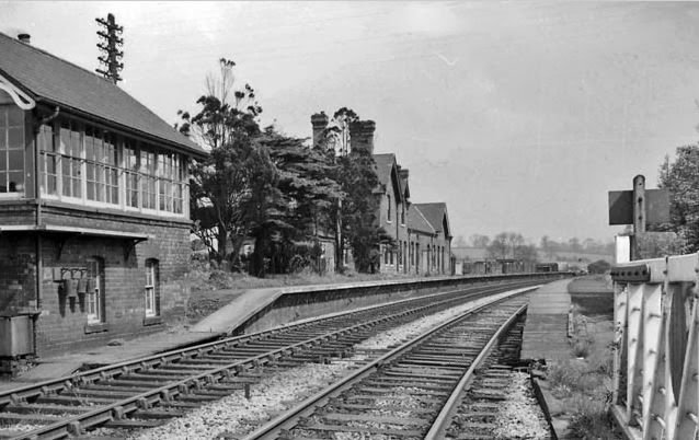 |
This is what it looked like all those years ago.
Both photos taken from the same spot. |
 |
| The platform has also been partly re-instated. |
 |
| Just past the station we see on the left the spire of All Saint's church in Breadsall, and the road which leads into the village. |
 |
| A seat and a bird table have been installed by the Derby Sustrans Rangers. |
 |
| Now we are on the original railway track level. |
 |
| But after another seat, run downhill to the crossing bridleway. The railway ran on top of the embankment here (left), crossing the bridleway by means of a high level bridge, since demolished. |
 |
We cross the Windmill Bridleway here. To the right it leads to Breadsall Hilltop where there once was a windmill and is now a public house, predictably called "The Windmill. To the left there is access to Brookside Road.
The brickwork opposite is all that remains of the railway bridge.
|
 |
| Inevitably a climb uphill now to regain track level....................... |
 |
| ....but well worth the effort. |
 |
| And another climb to the summit of the path. To the left here, the railway ran in a deep cutting to pass beneath the A608 road which lies just over the brow. Part of the bridge was demolished to facilitate road widening and so the greenway has to rise back to road level. |
 |
| The Greenway currently ends here at Sixoate Gate, but a further extension will soon be constructed.................. |
 |
........running initially along this path to cross the top end of Brookside Road and further on to cross the A608 road, subsequently running off-road past the nature reserve and on to Lime Lane near to the village of Morley. From there the ultimate destination of the Greenway, Ilkeston, can be seen.
|


No comments:
Post a Comment